British Virgin Islands: Boaters Advised Not to Sail in Exclusion Zone
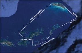
The Government of the Virgin Islands has introduced an exclusion zone that would limit marine traffic as a result of COVID-19.
Published 5 years ago
Press Release from the Government of the BVIs
Thursday, 11 June 2020 – 6:56pm
The Government of the Virgin Islands has introduced an exclusion zone that would limit marine traffic as a result of COVID-19.
Premier and Minister of Finance, Honourable Andrew A. Fahie said that unrestricted marine traffic and activity will be allowed only between 5:00 a.m. and 5:00 p.m.
The Premier said, “Unrestricted marine traffic and activity will be permitted East of 64*38.300’W on the south side of Tortola and an area East of the dividing line between the western most tip of Jost Van Dyke and Western most tip of Tortola.”


The Territory’s leader further stated that traffic through the exclusion zone and outside of the navigational limits is restricted and requires pre-clearance from the Multi-Agency Operational Command prior to transit.
Premier Fahie added that vessels fitted with Automatic Identification System technology will be required to use same while navigating within the Territorial waters, especially in the exclusion zone to make them easily identifiable to law enforcement from a distance.
Licenced or approved fisherfolk can contact 311 in advance of departure for their approval if they wish to traverse the exclusion zone. Boaters that enter the exclusion zone without prior permission will be in violation of Curfew (No. 21) Order, 2020 and can be penalised.
All cargo vessels and other vessels that have been granted permission by the Ministry of Health and Social Development, Environmental Health Division and the Joint Border Taskforce to arrive or depart the Territory are exempted.
The exclusion zone is an area west of 64*38.300’W on the south side of Tortola. This area is loosely described as a line between the westernmost tip of Norman Island and Nanny Cay and remains clear of USVI territorial waters and west of a dividing line formed between the westernmost tip of Jost Van Dyke and the westernmost tip of Tortola. The exclusion zone around the BVI encompasses the western tip of Jost Van Dyke and western tip of Anegada.
Read full press release here.
…………………………………………………………………………………………………………………………………..
This information has not been independently verified.
Related to following destinations: Beef Island, British Virgin Islands, Great Harbour, Jost van Dyke, Nanny Cay, Parham Town, Road Harbour, Tortola, West End (Sopers Hole)
Related to the following Cruising Resources: Caribbean Sea, COVID-19, Routing
